


The following is excerpted from the book “A History of Canada in Ten Maps” by Adam Shoalts and reprinted with permission from the publisher. Copyright © 2017 by Adam Shoalts. Published by Allen Lane, an imprint of Penguin Canada, a division of Penguin Random House Limited. All rights reserved.
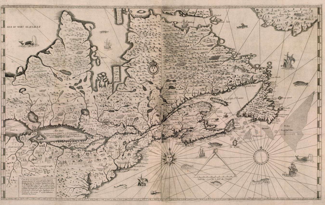
Champlain’s Map of New France
Champlain’s health, as he turned sixty-five, declined rapidly. On Christmas Day 1635, he died in his bed—a rare achievement for a man of action in his era. His death was greatly mourned, not only by the French colonists, but also by dozens of northern native nations from the Wendat to the Mi’kmaq—who had seen in Champlain an honest and brave man, and a loyal friend. They would not soon see his like again. The founder of Quebec was buried inside the town’s walls.
Champlain had successfully crossed the dangerous Atlantic some twenty-seven times, never once losing a ship. He travelled and explored widely, saw two great lakes, ran rapids in a canoe in a manner no European aside from Brûlé and a few of his other scouts had previously dared, fought in wars on two continents, and planted the first permanent seed of European colonies in Canada. He was, as French Canadians later named him, le père du Canada—“the Father of Canada.”
His legacy is perhaps most fully told in the maps he left behind— maps many consider to be among the greatest ever made by any single explorer. Looking at Champlain’s maps today, one is struck by their accuracy: they represent a great leap forward over all previous maps of North America. His masterful maps were the result of a complex, multi- layered approach that combined geographic data from many sources. First of all, Champlain had the maps of his predecessors to guide him—they were often crude and full of errors, but still provided a rudimentary base map. To these, Champlain could add his own detailed observations and corrections, the result of his many sea voyages to the waters off Newfoundland, Acadia, as far south as Cape Cod, and all through the Gulf of St. Lawrence, as well as his many canoe journeys. With his astrolabe and knack for celestial navigation, he recorded hundreds of sun and star observations that gave him his latitude. This helped fill in the details of his maps and correct previous errors. But most of his mapping remained essentially intuitive—sketching features that he saw from the deck of a ship or the bow of a canoe. It took a trained eye to pull that off with the degree of accuracy Champlain managed.
He had ventured far in his travels in the interior—all the way up the St. Lawrence from its mouth to the island of Mont Royal. He ’d ranged southward to Lake Champlain and had seen the peaks of the Adirondacks; northward he had struggled up the Ottawa River and over the height of land to Lake Huron. He journeyed through much of what is now central Ontario, and across part of Lake Ontario and south into Iroquois territory. All these lands he mapped as he explored them—pausing whenever he could to take readings with his astrolabe. And what Champlain wasn’t able to explore himself he dispatched his scouts—the coureurs de bois—to explore and report back on. He also incorporated into his maps the charts of other contemporary European explorers—like those of the English, who were busy exploring the Arctic regions in their quest for a northwest passage. Last, but certainly not least, Champlain drew from the knowledge of his aboriginal allies, whom he almost constantly asked about geographical matters. Several times he noted asking his native friends to draw birchbark maps for him. Undoubtedly, these maps filled in many of the final details on his charts.
Champlain was always revising his maps. His final version of his map of North America, published in 1632, shortly before his death, is a magnificent accomplishment. It reveals the outline of much of north- eastern North America, from Baffin Island in the north to Chesapeake Bay in the south, and west to the Great Lakes. The Atlantic seaboard is charted in impressive detail; earlier errors are gone from his map, and we can see clearly now the Bay of Fundy, Cape Breton, Prince Edward Island, the Gaspé, Anticosti, and Newfoundland. The St. Lawrence River is mapped from its wide mouth all the way to its headwaters on Lake Ontario. The Ottawa is mapped northward, not only as far as Champlain made it, but also, on the basis of his aboriginal reports, beyond. Lake Huron and Superior—here labelled as “Mer douce ” and “Grand Lac”—appear for the first time on a European map. They are large and not particularly well defined—since Champlain never saw Superior and only paddled Lake Huron’s eastern shoreline through Georgian Bay’s Thirty Thousand Islands. He didn’t know about Lakes Michigan or Erie—but he conjectured, from his native reports and Brûlé, that Huron drained through some unknown watercourse eventually into Lake Ontario. Of particular note is how Champlain paid great attention to labelling the homelands of many different aboriginal nations—indicating their villages with drawings of their longhouses. And for a lifelong sailor, it’s not surprising that Champlain liberally illustrated his map with sea creatures and ships under sail. On the technical side, he included an accurate scale and lines of latitude and longitude that correspond impressively to the measurements found on modern maps.
But although he set a new standard for accuracy, there remained much that Champlain didn’t know—much in fact that no one really knew. What lay beyond the Great Lakes to the west was a complete mystery to Champlain—even the Wendat had been unable to tell him anything about these lands—and he still wondered whether there might yet prove to be a passage to China. The northern seas beyond James Bay were also unknown to Champlain. These were questions other explorers would have to answer.
Read more in Community.