


This story is the 19th in our series on the hidden history of Vancouver’s neighbourhoods. Read more.
Despite the racism of Vancouver in the 1940s, Tong Louie and Geraldine Seto were skilled at navigating between Chinese and non-Chinese social settings. Both had graduated from UBC. Before he eventually became the philanthropist and businessman whose empire included Western Canada’s London Drugs pharmacies and IGA supermarkets, Louie travelled in the province in a beat-up Ford Model A as a salesman at his family’s wholesale grocery business. Meanwhile, Seto had grown up in the West End and was a devotee of the arts. A few months before their marriage in April 1941, Louie bought their first home at 5810 Highbury Street, in what is now the Dunbar-Southlands area. The move initially did not go well.
In a Vancouver Daily Province article cited in Tong: The Story of Vancouver’s Quiet Titan, 23 of Louie and Seto’s would-be neighbours appeared before Vancouver city council, urging its members to draft a by-law that would keep “Orientals” from buying or renting property outside “their own recognized localities.” A city alderman, H.D. Wilson, backed the Dunbar delegation. Asians “won’t comply with our standards,” asserted Wilson, who would support the incarceration of Japanese Canadians the following year. “Real estate values are falling. Where one Oriental buys property another follows.” The protest didn’t ruin the newlyweds’ plans, and they were soon welcomed into Dunbar by their neighbours.
At first glance, this unpleasant chapter in the history of Dunbar-Southlands—which runs from West 16th Avenue in the north to the Fraser River in the south, and from Mackenzie Street in the east to Camosun Street in the west—speaks to the privilege and NIMBYism of both the dour west-side residential neighbourhood of Dunbar and the expansive semi-rural properties of Southlands. “Our neighbours had last names like Fraser, MacDonald, and Stong,” Wiley Wei-Chiun Ho recalled in The Astronaut Children of Dunbar Street, a memoir about growing up with her siblings in the area in the 1980s as her parents worked in Taiwan. “We were now surrounded by young families and clean-cut dads who went to work in the morning and returned home before dark.” But a closer look at its rich history also shows long-running strains of diversity and radicalism.
For 3,000 years, long before European settlement, the area held the village of the Musqueam people, who named themselves after məθkʷəy̓ (“muthkey”), a river grass, that grew in their region and was, according to stories from elders, the result of droppings from a two-headed serpent that lived in what’s now known as Camosun Bog.
Dunbar-Southlands’ first European inhabitants were brothers Samuel and Fitzgerald McCleery, two would-be prospectors from Ireland, who took advantage of an 1860 law that gave land to settlers who cleared and farmed it. The McCleerys and other early settlers like Henry Mole and Hugh Magee lived in what is now Dunbar-Southlands alongside the Musqueam people, whose reserve was established in 1864. In the late 1870s, the Department of Indian Affairs rented some reserve land to Chinese vegetable farmers. (Musqueam elder Larry Grant, whose father was a tenant farmer from Guangdong province, China, on that land, embodies the enduring connection between those communities.) The reserve remains the home of the Musqueam people, although some of it is leased to homeowners and the Shaughnessy Golf & Country Club. At the south end of the area, a community of Japanese fishers were established on Deering and Celtic Islands in the 1890s. (The channel that separated Celtic Island, which was also the site of a cannery, was later filled in and renamed Celtic Avenue.) This area became part of South Vancouver in 1892.
Up the hill to the north, settlement began on newly logged land in 1912, when the Mount family built a shack at 3379 West 22nd Avenue. As homes began to appear among tree stumps and brush, families kept chickens and goats and maintained vegetable gardens.
The area became part of the city of Point Grey in 1909. Shortly afterward, American developer Charles Trotter Dunbar paid $35,000 to the BC Electric Company to run a north-south streetcar between established tram lines on West 41st and 10th Avenue. “Although Dunbar Heights is probably named after C.T. Dunbar,” Peggy Schofield wrote in The Story of Dunbar: Voices of a Vancouver Neighbourhood (published by Ronsdale Press, when it was owned by Dunbar-Southlands resident and retired UBC prof Ron Hatch), “there is no evidence that Dunbar Street is named after him.” Schofield noted that other streets in the area had been named after the sites of famous European battles, including one in Dunbar, Scotland, in 1650.
The tram line bankrolled by Dunbar helped establish a commercial strip running between West 29th and 25th Avenue in the 1920s (before the popularization of cars simplified crosstown shopping trips). The first store, Scott’s Grocery, opened in 1922 near West 29th. By 1927, there were more than two dozen businesses on the strip. The introduction of the Dunbar Theatre in 1935 brought further excitement to the area. A redevelopment proposal currently being discussed promises to build around one of the city’s few surviving neighbourhood movie houses and restore the art deco exterior that was lost in a 1964 renovation.
As part of Point Grey, Dunbar-Southlands became subject to Canada’s first zoning by-law in 1922, which maintained the primacy of single-family residential homes in the area. Builders of that era, working from pattern books, built houses in the style of California bungalows with deep eaves, followed by English Tudor-style homes with stucco exteriors and steep roofs. (Subsequent waves of building would bring everything from turreted “castle”-style bungalows to Vancouver Specials and a residence designed by Arthur Erickson at 6095 Balaclava Street.) When UBC opened its Point Grey campus in 1925, Dunbar soon became one of the prime residential areas for professors and basement-dwelling commuter students.
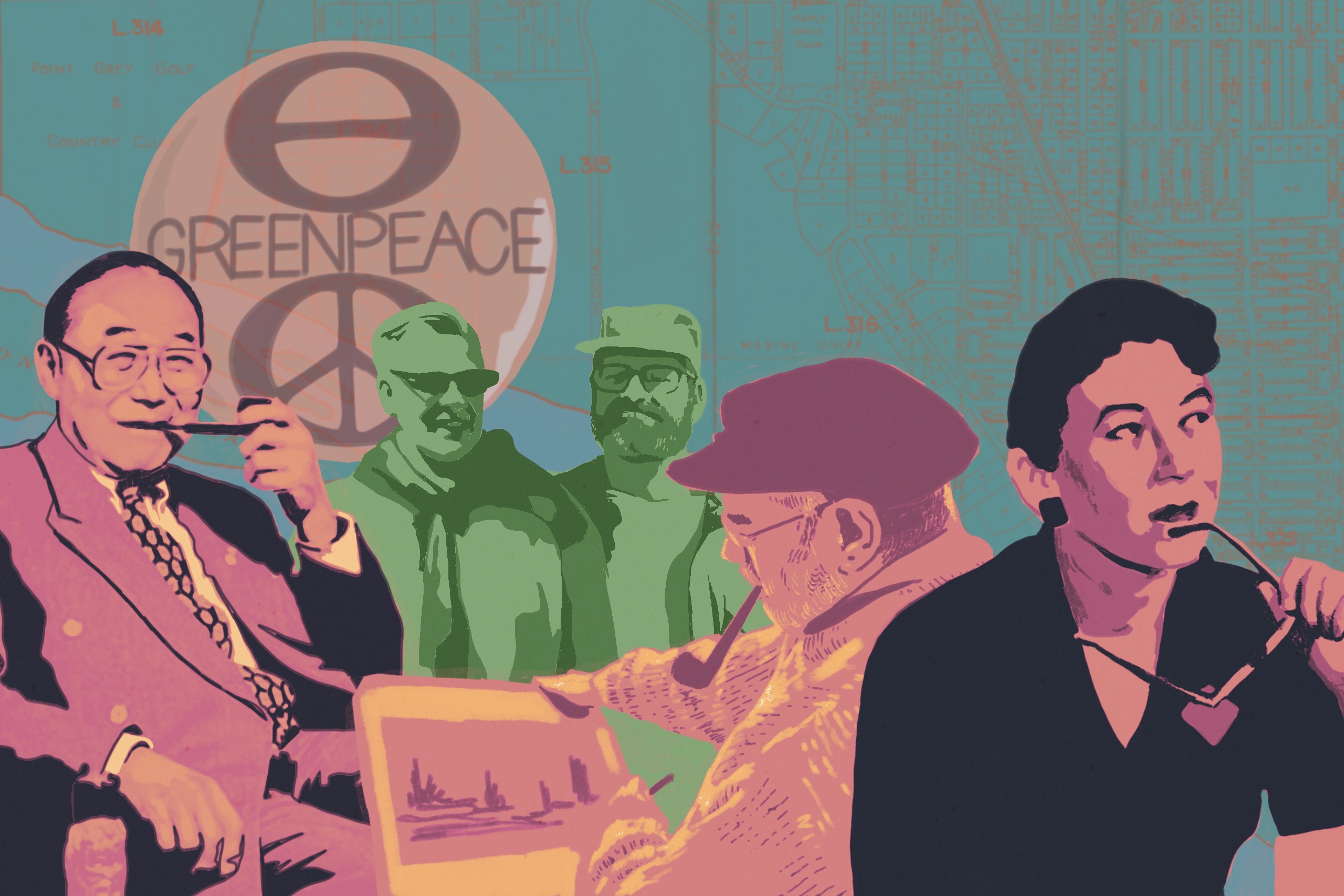
The presence of students and intellectuals in the area made Dunbar-Southlands an unlikely site for radicalism. A beatnik coffee shop called The Black Spot operated from 4345 Dunbar Street from 1959 to 1962. Among its patrons was Allen Ginsberg, who would go on to lecture at UBC. Poet bill bissett lived in the apartment above. “You’d look in there and it was black as all get-out,” Doug Edwards recalls in The Story of Dunbar. “The later hippie generation [with] the long hair and the beards and all that—the Black Spot predated all that. It was the T-shirts, sweatshirts and goatees, beards, bongo drums, and beat poetry.” A little over a decade later, Greenpeace was launched at the home of Jim and Marie Bohlen on 3504 West 19th Avenue. And while Dunbar-Southlands has included many artists such as the novelist Margaret Laurence and carver Douglas Campbell Baker (who lived on the Musqueam reserve), none could match the flair of Toni Onley. In 1984, the renowned landscape painter helped change Canadian tax law, which then deemed an artist’s unsold inventory taxable, by threatening to set his paintings ablaze on Wreck Beach. Onley, who piloted himself to remote settings for his work, would die in a 2004 plane crash.
These forays from convention notwithstanding, Dunbar-Southlands’ development has been stubbornly shaped by the zoning restrictions that transformed it from a stumpy wasteland over a century ago. Despite changes in both the city and the neighbourhood, Dunbar-Southlands remains an affluent area based around single-family homes. Residents have been active and vocal about efforts to densify the area, with some wanting gradual, mindful shifts from the norm—and others rejecting any deviations from it wholesale.
Campaigning quashed the Penta Co-operative Housing Association project on city-owned land near Camosun Bog (the land was later sold by the city as lots for single-family homes) in the 1970s and a Polygon Homes proposal to build a townhouse and apartment complexes on Alma Street, between West 27th and 29th Avenues, in the 1990s. In West Southlands, neighbourhood activists pushed back on city efforts to fill in wetlands near Southwest Marine Drive and West 49th Avenue, pushing instead for that land to be added to Musqueam Park.
Even when development has gone forward, it hasn’t proceeded smoothly. In 2007, two new homes, which were built despite resident protests on an undersized lot, were damaged by fire. VPD investigators described the damage as “suspicious.” In 2011, a supportive social housing complex at West 16th Avenue and Dunbar Street, managed by Coast Mental Health, opened despite complaints from locals fearing increased crime and lowered property values. And while arson was ruled out as the cause of the fire that toppled a tower crane at an apartment building site at Dunbar Street and West 41st Avenue in March 2025, the conversation about the changing face of Dunbar-Southlands does not lack passion and engagement.